Mapping Wildfire Stucture in Real-Time: Head, Flanks and Tail
- Hanna Wellenberg

- 1 day ago
- 3 min read
When responding to a wildfire, knowing the perimeter is only part of the picture. What matters just as much is understanding how the fire is behaving across that perimeter in real time.
For operational teams, identifying the head, flanks, and tail of a wildfire is critical. These different parts of the fire do not behave the same way, and they do not pose the same level of risk. Recognising those differences early helps responders predict fire spread, prioritise suppression efforts, and improve crew safety.
Why Fire Structure Matters Operationally
Wildfires develop asymmetrically. Wind, slope and fuel distribution drive uneven spread rate across the perimeter:
Head: Typically exhibits the highest rate of spread and intensity, often dictating overall fire progression.
Flanks: Can transition rapidly depending on shifting wind conditions, making them critical for containment strategy.
Tail: May appear less active but still presents risks, particularly in variable terrain or changing weather.
For incident commanders, these distinctions are not theoretical. They directly inform tactical decisions such as line placement, resource deployment, and evacuation planning.
The challenge with live wildfire observation
Many wildfire teams already use drones, aerial imagery or other similar tools to gain visibility on the incident. These tools are valuable, but they often do not provide a continuous and shared operational picture.
A live drone feed gives detail, but only within a limited field of view. Manually drawn perimeters depend on individual interpretation and quickly become outdated.
From perimeter mapping to real-time structure insight
This is where CHRIS adds value.
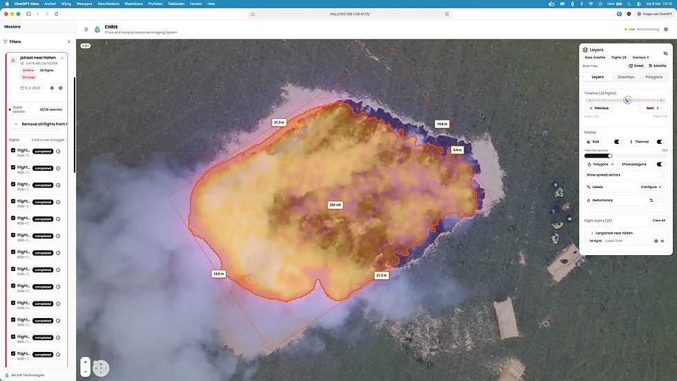
CHRIS transforms aerial imagery into a continuously updated, georeferenced wildfire map in near real time. It automatically detects the fireline and draws the perimeter as a polygon, giving teams an up-to-date outline of the incident without relying on manual plotting.
As shown in the image above, this live-mapped perimeter also makes it easier to distinguish the head, flanks, and tail of the wildfire at a glance. That gives responders not just a fire outline, but a clearer understanding of how the incident is structured and where the main risks are developing.
Instead of scattered observations or a single static map layer, responders get a live operational overview that updates as the incident evolves.
That means teams can do more than see where the fire is. They can begin to interpret how it is moving and which parts of the fire demand the most attention.
With this kind of live overview, responders can:
Identify the active head of the fire and monitor its direction of spread
Detect changes along the flanks before they become larger containment problems
Maintain visibility on the tail and spot areas that may reignite or remain operationally relevant
Work from an automatically updated fireline polygon rather than delayed manual perimeter sketches
This turns aerial observation into practical situational awareness.
Faster decisions under pressure
In wildfire response, timing matters. A small delay in recognising a shift in fire behaviour can quickly affect safety, coordination, and containment strategy.
With a continuously updated map, changes in fire direction can become visible earlier. Resources can be reassigned based on current conditions. Containment tactics can be adapted with greater confidence. Most importantly, teams across the incident can work from the same operational picture.
That shared clarity becomes especially important during fast-moving incidents, where conditions can change in minutes rather than hours.
Want to see how CHRIS helps teams map wildfire progression and structure in near real-time?
By automatically generating fireline polygons from aerial imagery and turning them into a live operational map, CHRIS gives responders the clarity they need to act faster, coordinate better, and make safer decisions in the field.
Comments