MEJOR Technologies Opens CHRIS Beta Testing to First Responders and Operational Teams
- Nathaniel Osborne

- May 22
- 3 min read

On May 20, 2026, the Mayor of Amersfoort visited the MEJOR Technologies office to mark the official launch of the new CHRIS beta.
We are opening this beta to first responders and operational teams who work in fast-moving environments and want a clearer view of what is happening on the ground. The beta will run during May and June 2026, and it is available at no cost.
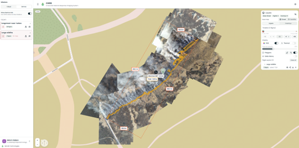
The beta is designed for real-world use in fast-moving environments where teams need a clearer view of what is happening on the ground. CHRIS brings live 2D overview maps, fire perimeter polygons, and improved situational awareness while the drone is still flying.
What the new CHRIS release adds
The updated CHRIS release helps teams build a better operational picture in the field by making it easier to:
Create 2D overview maps in real time while flying
Detect fire and draw polygons around affected areas
Distinguish fire, vehicles, and people more clearly
Track changing conditions as an incident develops
CHRIS works with DJI Mavic, Matrice, or higher-class DJI drones that can be connected quickly in the field.
Built for fast-changing situations
CHRIS is especially useful in situations where speed and clarity matter most. That includes wildfire tracking, industrial fires, flooding, earthquakes, and other incidents that can change rapidly.
By creating a live 2D overview during flight, CHRIS helps teams share a common picture of the situation sooner. Fire fronts, affected areas, and important objects can be identified more easily, which supports better coordination in the field and with incident command.
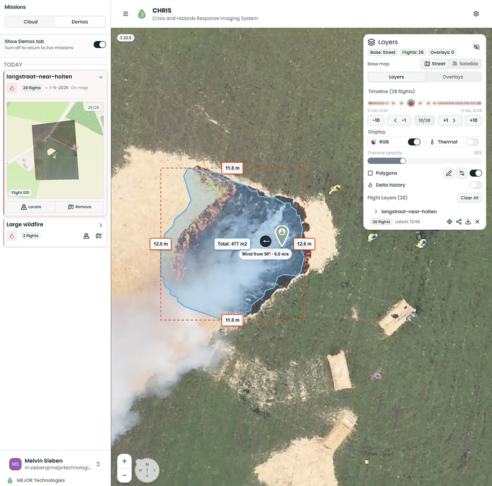
Fire detection while flying

One of the most valuable parts of the beta is fire detection during flight. CHRIS uses drone IR sensors to detect visible fire patterns and overlay polygons and labels that help teams understand the affected area more quickly.
It also includes delta history, so users can compare how the incident changes between photos and see spread over time.
Perimeter polygons and incident spread
Perimeter overlays make it easier to communicate how an incident is developing. Instead of relying only on static imagery, CHRIS adds a clearer visual layer that supports team communication and post-incident review.
After the event, teams can also analyze the complete spread over time, making it easier to understand how the incident evolved.
Beta invitation
We are inviting drone operators from emergency services to join the CHRIS beta for free.
With this new release, we will also be onboarding teams in other countries and regions such as Sweden, Portugal, and the United Kingdom, so the beta is not limited to one type of operating environment.
We are especially interested in hearing from teams working in wildfire response or other fast-moving incident environments, but the invitation is broader than that. If your work depends on clearer situational awareness from the air, we would be glad to have you involved.
All we ask is feedback in return.
If you join the beta, you will have one full month of access at no cost. Onboarding is designed to stay lightweight: we expect about one hour for the initial setup, where we connect your drone to CHRIS and walk through the basics. After that, we ask for at least one feedback session so we can learn from your experience and improve the system.
In return, we want to understand what helps, what gets in the way, and where CHRIS can do better.
If you would like to read more about CHRIS before applying, you can learn more about the system and how it supports real-time incident mapping here.
If you are interested in the free beta, please fill out the form on our website or click here. We would love to see what this technology can do in your environment.
The goal of this beta is simple: work with the people who need this kind of tool most, and use their feedback to make CHRIS better for real-world use.
Comments