From Wildfire Risk to Smarter Action
- Nathaniel Osborne

- Apr 28
- 4 min read
Updated: May 11
Wildfire risk is no longer a problem that can be managed with broad regional warnings and static hazard maps alone. For the organisations responsible for protecting land, infrastructure, communities, and portfolios, the more important question is not simply where risk exists, but where action should start.
That is exactly where LUCI stands out.
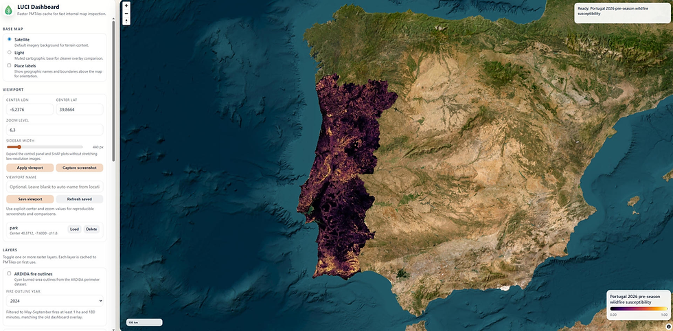
LUCI is MEJOR's wildfire susceptibility intelligence platform, built to help organisations make better prevention decisions before ignition happens. It combines high-resolution 10 m mapping, seasonal and in-season risk views, explainable AI, and machine-learning modelling that can be trained and adapted for different geographic regions and wildfire environments.
For buyers evaluating wildfire tools, that difference matters. Many platforms can show risk. LUCI is built to help organisations act on it.
Wildfire Risk Is Now a Prioritisation Problem
Most organisations do not struggle because they know nothing about wildfire risk. They struggle because risk appears across too many places at once.
One forestry agency may need to decide which treatment areas deserve funding this season. Another land manager may have to choose between thinning, fuel breaks, or access improvements across thousands of hectares. Utilities may need to focus inspections and vegetation management along the most exposed corridors. Insurers may need to distinguish between properties inside the same broad hazard zone but facing very different local conditions.
In each case, the problem is not awareness. It is prioritisation.
Broad fire danger ratings, static hazard zones, and generic regional indicators can be useful, but they often leave decision-makers with the same unresolved question: where should limited resources go first?
What LUCI Does
LUCI identifies wildfire susceptibility at a highly local level and helps explain the factors behind that susceptibility.
It is designed for organisations that need to allocate limited prevention budgets across large areas, justify decisions to stakeholders, and integrate
wildfire intelligence into real planning workflows.
LUCI supports this through:
10 m x 10 m wildfire susceptibility mapping for localised insight
Seasonal views for pre-season planning and budget allocation
In-season views that add dynamic weather data, shifting the model from longer-term susceptibility analysis toward short-term forecasting and operational reprioritisation during fire season
Explainable AI showing when, where, and why susceptibility is elevated
Delivery through dashboards, APIs, GeoTIFF/COG exports, and GIS-compatible outputs
Country-adaptable modelling rather than a one-size-fits-all wildfire index
Together, these capabilities help teams move beyond general wildfire awareness and towards targeted, evidence-based prevention planning.
What That Means In Practice
Consider a forestry agency entering fire season with a limited budget for treatment work. LUCI can help the team compare treatment blocks, identify which areas are most likely to benefit from action first, and adjust priorities as weather conditions change.
That kind of insight helps organisations:
prioritise fuel treatments and inspections
allocate limited prevention budgets more effectively
justify decisions to regulators or stakeholders
focus operational resources where intervention matters most
The value is not just in seeing risk. It is in making the next decision more defensible.
What Makes LUCI Different
LUCI is not designed as a static map, a generic fire weather index, or a full incident-response platform.
It is built as a pre-ignition decision layer.
That means LUCI is strongest when organisations need to decide where prevention work should happen before a wildfire starts. It gives teams a more precise view of susceptibility, then helps explain what is driving the risk so decisions can be defended internally and externally.
That explainability is important. A red zone on a map may signal concern, but it does not always help a field team, board, regulator, insurer, or land manager understand why action is needed. LUCI is designed to make that reasoning clearer.
This makes the platform especially useful when decisions need to be:
geographically precise
operationally actionable
explainable to non-technical stakeholders
updated across both planning season and fire season
integrated with GIS, underwriting, asset-management, or land-management workflows
Where LUCI Creates Value
LUCI is relevant across several wildfire-exposed sectors.
For landowners, estates, timber portfolios, and conservation managers, LUCI can help prioritise fuel treatments, thinning, prescribed burning, access improvements, and seasonal planning.
Forestry agencies and municipalities can use LUCI to support prevention planning, preparedness, grant applications, and cross-agency coordination through one shared risk layer.
Utilities and infrastructure operators can use it to rank corridors, assets, and maintenance zones so inspection and vegetation-management work is focused where it matters most.
Insurers and reinsurers can use LUCI for portfolio steering, mitigation programmes, and more localised wildfire exposure assessment, especially for rural, forestry, agricultural, and land-heavy portfolios.
Across these use cases, the value is consistent: LUCI helps organisations focus limited resources on the places where action is most justified.
From Knowing Risk to Acting on It
Wildfire prevention depends on better decisions before ignition.
That requires more than broad warnings. It requires localised intelligence, regular updates, and a clear explanation of why one place should be prioritised over another.
LUCI gives organisations that decision layer.
By combining high-resolution susceptibility mapping, seasonal planning views, in-season reprioritisation, explainable AI, and enterprise-ready delivery formats, LUCI helps teams plan earlier, act with more confidence, and defend their prevention decisions with better evidence.
In a world where wildfire risk is increasing and prevention budgets are limited, the most important question is not simply where risk exists.
It is where action should start.
LUCI is built to help answer that question.
To learn more about how LUCI supports forestry agencies, insurers, land managers, utilities, and other wildfire-exposed organisations, click here.
Comments